
This post is also available in: German
Mt Everest is an attraction: every spring media report about Everest-climbers, sherpa and tourists. But is climbing Mt Everest still an adventure?

Oil Painting, Portraits and Landscape Painting
Ölgemälde, Porträt, Landschaftsbilder
135 * 120 cm, 2012
There are two main routes onto the tallest mountain of the word: From
There should be around 20 routes from all sides leading to the top, but this two account for app. 95% of the traffic. For a map and more information on Mt Everest click here.
Mt Everest – like the other two of the high 8.000er mountains, K2 and Kangchenjunga – requires a third camp in the death zone because of the height. Most climbers need four days up and one to two days down to reach the top although the record is 8 hours 10 minutes from base camp.
Landmarks climbing Mt Everest from South
It is easier to climb the mountain from the south, but weather can be changeable.
This routes mostly starts in Namche-Bazar, which hosts the Syangboche Airport and is home to many Sherpa who are in the tourism business. Namche is the main trading center and hub for the Khumbu region with many Nepalese officials, a police check, post, a bank, and even a beauty salon.
Walking up the Goyko valley the countless tourists pass attractions like the “most beautiful mountain of the Himalayas”, Ama Dablam, and they walk around Nuptse in order to reach the base camp.
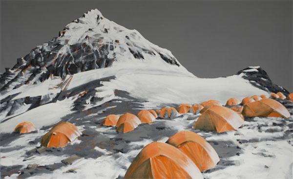
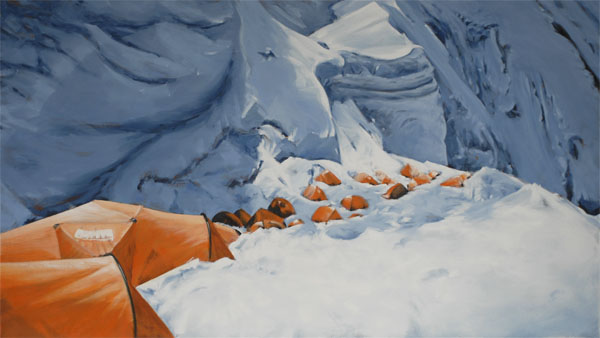
This base camp is located on 5.400 meters height – almost the height of the tallest mountain of Europe: Mount Elbrus. Meanwhile the base camp offers amenities such as showers, toilets, medical treatment, helicopter rescues and chocolate bars. But is is also dangerous: 18 persons died when an earthquake destroyed the base camp in 2015.
The Mt Everest base camp is located on a glacier in front of the Khumbu icefall.


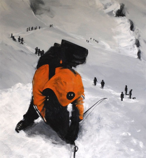
The Khumbu-Icefall is the first part of the ascend and one of the most hazardous glaciers on the world. It moves about a meter every day. This leads to new crevasses which could be five meters wide and dozens of meters deep.
Sherpa equip the whole mountain with fixed ropes every year. This is especially risky in the Khumbu-Icefall. In 2014 an avalanche killed 16 Sherpa and in 2015 the fixed rope was destroyed by the earthquake. No wonder that Sherpa are on strike.
Onto Everest via Lhotse face 
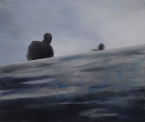
Clouds above silent valley

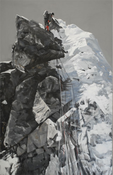
Camp 1 and camp 2 are situated above the icefall in the three kilometer long silent valley. The western cwm, as it is also called, reaches until the 1.000 meter high Lhotse face which leads to the south col. There, in the Lhotse face the famous photos of climbers walking one after another have been shot (after I painted it). Also camp 3 is located there.

220 * 135 cm, 2014
The last camp is situated directly on the south col in 8.000 meters height. There, mountaineers have little air – the death zone starts here. But they might have a great view on the last 848 meters. If clouds and own condition allow for it, climbers can almost see all the last walk (the south-east ridge) up towards the south summit in above painting. The marvelous south-face is to the left and the dangerous east-face (Kangshung face) is hidden to the right.

Oil Painting, Ölgemälde
2015, 185 cm * 290 cm
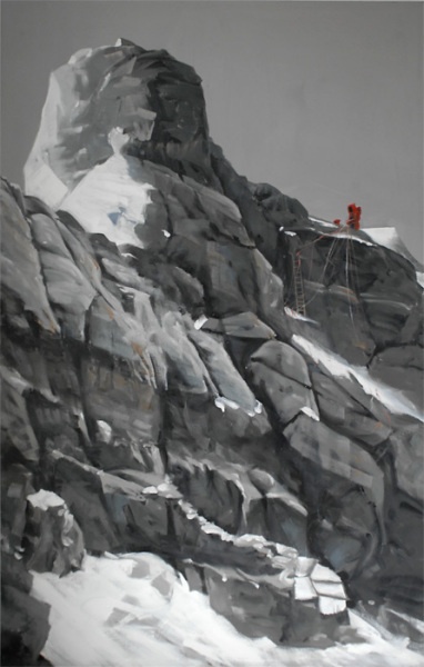
Shortly after the south summit the Hillary-Step waits on the exhausted climbers. This rock offers ten meters vertical climbing – a real landmark shortly before the summit and first climbed by Sir Edmund Hillary. This rock formation frequently causes traffic jams although there are fixed ropes. It is discussed to fix ladders there or open a second route further left.
Climbing Mt Everest from North
This is the longer journey but it can be cheaper if a permit is granted.
Coming from north, people need to pass remote Tibet. The advantage is that they can drive all the way to the northern base camp on 5.100 meters height. This is also a disadvantage if driven too fast. Morgan Boisson is an example for people who died in the base camp from anoxia.
The north face of Mt Everest is daunting – the summit can be seen from a large distance with its steep triangle and the two hazardous couloirs, the Norton-Couloir and the Hornbein-Couloir.
Avalanche on North-face 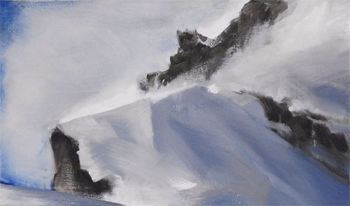
North-ridge close to the summit


For this reason the normal route avoids this wall and leads via the east Rongbuk-Glacier around the 7.000er Changtse to camp ABC, which is located on almost 6.500 meters height. From there the first high camp – the north col can be seen. It is 1.000 meters lower than the south col and farer away from the summit. The real climb starts from here.

Landscape Painting, Landschaftsbilder
230 *130 cm, 2014
The north-ridge gets difficult quickly. But, if not caught in a storm, mountaineers have a view on the famous and hardly climbed pinnacles on the North-ridge.
Storm 
Pinacles on the North-ridge


Two more camps are located on the north ridge. For the reason of the large distance to the summit, camp 3 is located on 8.300 meters height – in the mid of the death zone and higher than most 8.000er mountains.
From there, climbers need seven to eight hours to the summit. Not without obstacles: the three attractions first, second and third step block the way.

Oil Painting, Ölgemälde
2014, 185 cm * 290 cm
Especially the second step is so challenging that most mountaineers prefer the ladder which is fixed there. Oftentimes they pay with congestion, frostbite and anoxia. The legendary mountaineer George Mallory did not have this ladder. His body has been found shortly below the second step.
Again and again people die on the last meters to the summit. For instance Tsewang Paljor in der Green Boot Cave, David Sharp or Francis Arsentiev.


Oil Painting, Ölgemälde
135 cm * 120 cm, 2010
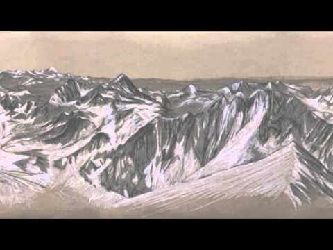
Summit and Panorama from Everest
An awesome view is waiting for those arriving at the small Everest summit.


Often there is a party going on up there celebrating the rare occasion. Most successful climbers rest only a short time before going down. The descend to the next camp lasts as long as the ascend.
Climbers are on the height of passenger jets flying and on a good day they can see six other 8.000er amongst other attractions. Not all mountaineers have the time to enjoy this view or take even panorama-photos. For this reason I drew a 360° panorama of the view from Everest summit.

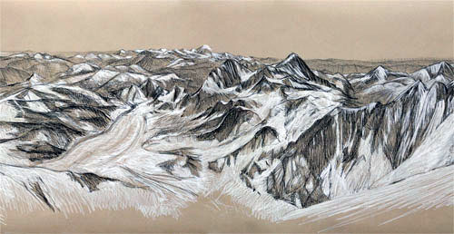
Chalk and Charcoal on Paper, Kreide und Kohle auf Papier
750 * 100 cm, 2013
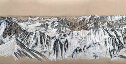
South 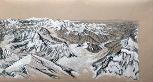
West 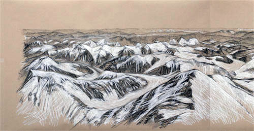
North


The panorama is also available on youtube:

Hey! I’ve been working on some of my own art recently and I’m having trouble finding the location of Green Boots cave. I’m aware it’s under the First Step, but I can’t pinpoint the exact spot. If you could maybe send pictures to my email, that would be awesome!
Best Regards,
Connor
It is here https://www.staeudtner.com/de/allgemein-de/green-boot-hoehle/attachment/ausstellung-juergen-h-staeudtner-3/
and there https://www.staeudtner.com/allgemein/into-thin-air/#Paljor
Hi Sir,
Thanks for the informative article. I am just reading up Jamling Norgay’s article “Touching my Father’s soul” and he mentions a landmark on the Everest during climbing the southern route called – Balcony. In your article above, could you help advice where does it fit in amidst the landmarks mentioned in the southernly ascent?
Thanks and Happy blogging
Best Regards,
Pallavi
Dear Pallavi, sorry for my late response.
The balcony on the Southeast ridge is dividing the south wall, specifically the triangular face, from the dangerous east wall of Everest. You should have a very good view toward the Kangshungu East face from there. In the painting South-Col the balcony should be the part after the first larger elevation on the right side of the mountain counted from the top (the South-Summit presumably).
Best regards, Jürgen
Pingback: Subject: High Altitude | Jürgen Stäudtner
Pingback: Exhibition WP8 | Jürgen Stäudtner
Pingback: Ausstellung WP8 | Jürgen Stäudtner
Pingback: South col of Everest | Jürgen Stäudtner
Pingback: Khumbu Icefall | Jürgen Stäudtner