This post is also available in: German
Little people so far had the opportunity to enjoy the breathtaking view from the summit of Mount Everest.
Many details can be seen because the mountain is so much higher than its surroundings. With good weather conditions six other 8.000ers and in total thirty of the highest mountains of the world can be seen.
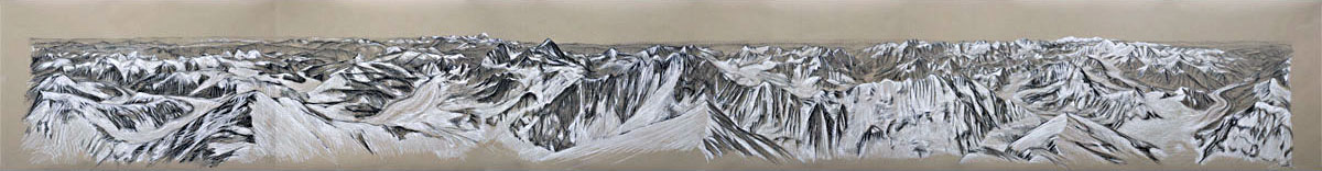
Chalk and Charcoal on Paper, Kreide und Kohle auf Papier,
750 * 100 cm, 2013
You do not need to suffer low oxygen supply, bad weather and storms, congestion of climbers or simply exhaustion.
This post describes which mountains you see, shows a video of the panorama and gives you a map of the Himalayas.
Mountains seen from the top of Mt Everest
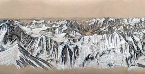
North
The North shows endless Tibet. Still two of the highest mountains on earth are to be found here: Changtse (in the foreground left) and Khartaphu.
The main route from the north can be seen with the ABC camp to the right of Changtse, the north col on 7.000 meteres and the North-East ridge with the three step steps to be passed. The base camp is not on this excerpt since it is located a little more to the left.
East
Makalu (5th highest mountain) and Kantschenjunga (#3) are the most impressive silhouettes.
Makalu (almost in the center) means “black mountain” because early in the morning sun rises behind the mountain and it remains dark for long hours.
Kantschenjunga (in the middle of the background) is quite in the east of all the Himalayas. To the right of Makalu you see Darjeeling in India.
The Kangshung face (East-face of Everest) falls down in the foreground. Only little can be seen since it is steep.
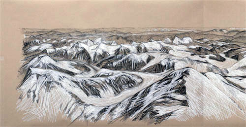
South
In the South Lhotse (#4) and Nuptse are closest and define the border of the silent valley and the Khumbu ice fall.
Lhotse is in the left of this part of the drawing with the south-summit of Everest in the foreground. This is an area of the mountain with many dead bodies. To the right you see Nuptse in the front and a little behind, in the center, Ama Dablam, which is considered as one of the most beautiful mountains on earth.
In the back, to the right of Ama Dablan, you see the the valley most expeditions take reaching to Namche Bazar, Lukla airport and finally Nepal.
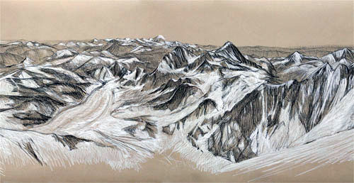
West
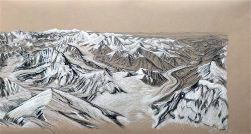
In the West the main arm of the Himalaya is glittering in the sun with Cho Oyu (#6), Manaslu (#7, in the very back), Sisha Pangma (#14) and Gyachung Kang (#15). Also Pumori – considered as the best viewpoint for Mount Everest – is found here in the left center.
The foreground shows the west ridge leading to Lho La Pass on 6.600 meters height. To the right the Rongbuck glacier with the north base camp is situated – expeditions from the North take this way until the turn to your right behind Changtse (in the foreground to the right).
The north-face between the West-ridge and Changtse is also steep and not on the panorama.
Video of the Mt Everest 360 Panorama View
Click for an interactive version of a 360 degree panorama drawing of view from Mt Everest summit.
Click here for the same interactive view with additional descriptions of the mountains seen.
Where is Mt Everest located?
The Himalayas consist of parallel mountain ranges: the Sivalik Hills on the south; the Lower Himalayan Range; the Great Himalayas, which is the highest and central range; and the Tibetan Himalayas on the north.
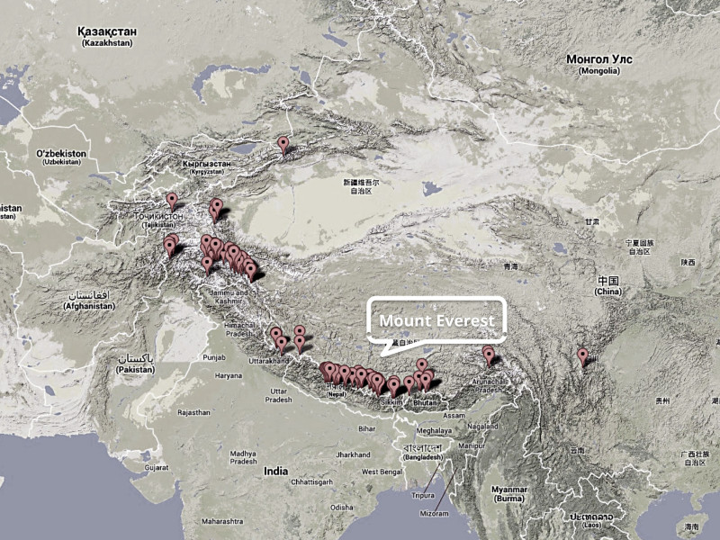
This map shows the 100 highest peaks of the world.
Borders
The Karakoram (with the K2, the Broad Peek and the two Gasherbrums) are generally considered separate from the Himalayas because the Indus-Knee seperates the mountain ranges. The only 8.000er in the West of the Himalayas is Nanga Parbat.
All other 8.000 m (26,000 ft) peaks are located towards the right of the Great Himalays.
In the East of Nepal, the Himalayas rise to the Kanchenjunga massif on the border with India, before the get smaller in the Indian state of Sikkim, formerly an independent Kingdom, and the ancient Buddhist Kingdom of Bhutan.
Mt Everest
The mountains in the vicinity of Mt Everest form a horeseshow. The way towards the south base-camp leads through a series of valleys before following the Khumbu glacier.
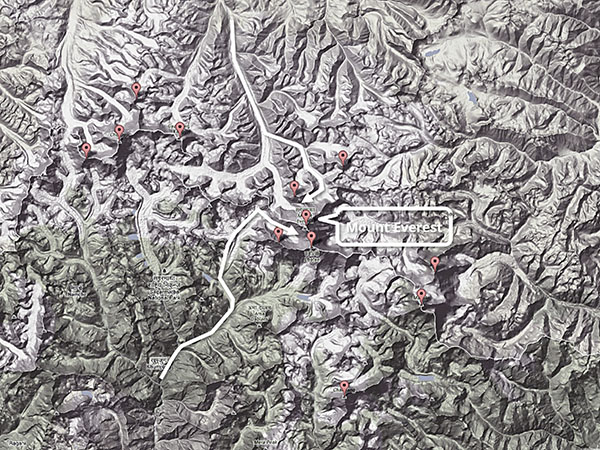
In the north, the Rongbuk glacier leads the way from Tibet to Everest.
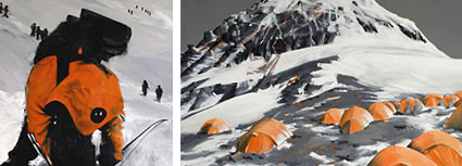
This painting is part of the set Landmarks of Everest – routes on the mountain shown as paintings. Click here for more!


Pingback: Legends of Everest | Jürgen Stäudtner
Pingback: Text zur Ausstellung: Dach der Welt | Jürgen Stäudtner
Pingback: About this page in 2015 | Jürgen Stäudtner
Pingback: 360° Panorama Drawing of view from Mount Everest summit | Jürgen Stäudtner
Interestiing information!! I liked the portraits (legends of Everest) and Sherpas!!
Thank you Consuelo!
Pingback: Thank you from a German Painter | Jürgen Stäudtner
hi, really like your artwork of peak 15 [ everest ] i would like a drawing looking towards the north face of everest. as i,am gonna get a tattoo. your drawings look like what i,m looking for. send me some images. many thanks-dude.
Hi Glenn,
see my E-Mail!
Thx, Juergen
Pingback: Subject: High Altitude | Juergen H. Staeudtner
ow much cost for trekking mount everest.
And how much time to complet mount everst.
Pls give some basic information of mount everest.
Tanna, I am only a painter.
I am sorry, but I cannot help.
Regards, Juergen
awsome never thought that was so high wish i could climb alittle of it!!!!!!!!!!!::)))
Keep up the good piece of work, I read few posts on this website and I conceive that your site is really interesting and contains circles of superb information.